Place: Hayward Regional Shoreline, Hayward, California
Coordinates: 37.62334, -122.13726
Difficulty: very easy
Last Saturday was a beautiful day and after sitting in the house long enough, all of us quails went for a short and highly rewarding hike at the Hayward Shoreline. You can click on the photographs to get a larger view.
If any of you wondered what is the brown building seen from west hy92 right before the toll plaza of San Mateo bridge, it is the Hayward Shoreline Interpretive Center (HSIC), which is part of the Hayward Area Recreation and parks District (H.A.R.D.). At this building is the trailhead of the 7-mile long portion of the S.F. Bay trail, which runs all the way to the San Leandro Marina. Having the little quail chikas in tow we hiked only 0.8 mile out, reached the open bay and returned. Our hike is labeled in yellow on the bottom of the map I downloaded from the EBRPD site.
We arrived the HSIC at about 2:30 pm. It was sunny but very windy. We were glad to have brought our sweatshirts. The tide was at its lowest I've ever seen there, and all the mud flats were exposed and marked with numerous tracks. Birds, mostly, but other animals too.
 |
| Snake tracks |
 |
| Rabbit tracks |
We entered the HSIC and spent some time inside. The HSIC has a lovely exhibit room with several tanks housing a variety of bay fish, crustaceans and molluscs, including small sharks whose feeding times are public events. There weren't many people there at the time we were ther so the little chikas got the full attention of the naturalist, who brought out a gopher snake for them to hold and admire. The center's objective is the education of people about the bay shoreline habitats and the importance of keeping the bay and its shores clean of pollution and refuse. Many of their programs are for families and are very much focused on the education of children. School field trips to the HSIC are a wonderful opportunity to expose children to these wonderful programs of environmental education.
On the beams extending from the brown HSIC building there were Barn Swallows perching, or flying about, busy catching insects or carrying mud to build their nests.
 |
| Barn swallow |
 |
| Least Sandpiper |
The trail is gravel-packed and wide, and is very popular among bikers. The slough stretches along the path all the way to the bay. Man-made passages connect the array of sloughs and ponds in the entire area and control the flooding. This is how some areas appear full while others right next to them at the same height appear empty. The muddy banks of this slough were completely exposed in the low tide and only a small trickle of water run in the middle.
The areas that have been exposed for a while were crusted and cracked:
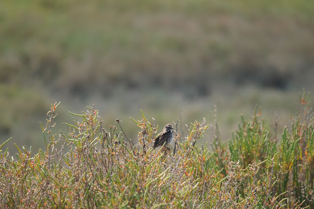
The whole area is flat with no land features to break the wind. The vegetation consists of low shrubs and annuals, all salt-resistant. One of the most common shrubs in this habitat is the pickleweed, which is, in fact, edible. Here is a cute little sparrow perching on the pickleweed:
 |
| A song sparrow |
All along the path we saw Forster's Terns flying about and heard their high-pitched cries.
 |
| Forster's Tern |
This simple, plain bridge functions also as a scaffold for cliff swallows building their mud nests right under it:
 |
| Cliff Swallows building their mud nests |
Just before the slough reaches the bay it widens into a small pond that provides a foraging and resting place for a number of bird species. In that one little pond I saw a great egret, a cormorant, a couple of mallards, a curlew, and two Forster's terns that came to rest on a bar over the pond.

On the other side of the slough was a larger, shallow pond where quite a few sandpipers waded about with their bills in the water.

Despite it being spring time, I saw little variety of blooming plants and of those, the yellow was definitely dominant. The mustard, which is an invasive species, creates bright yellow mats all over the land areas.
And I also saw this tiny composite flower, so low that it's barely detectable:
At the bay we turned around and headed back. The tide was coming in and the slough was filling with water once again.
On the horizon, Mount Diablo is visible (beyond the new power station construction site)
And just before returning to the HSIC we saw a male mallard warming in the sun. As we passed it, it jumped into the water with annoyed quacks.
 |
| A sitting duck |


No comments:
Post a Comment